Newsletter 12
May 2017
Editors view
Dear All,
” Digital Workflows for Heritage Conservation “. This is the title of our 26th CIPA symposium. In 2017, the two-yearly CIPA symposium has landed in Ottawa (Canada) from August 28 to September 1. CIPA is very pleased to welcome everybody that cares for cultural heritage to join us in this unique event.
Carleton University and the Carleton Immersive Media Studio, Mario, Stephen, Christian and a whole team are doing their best to organize an excellent event and offer a unique chance for educators, professionals, heritage institutions, and managers in the cultural heritage field to share, exchange, and explore new methods, best practices, and research results in the area of cultural heritage documentation. Visit the official symposium web page for more information regarding registration, the programme, the venue and everything else related to this event.
In the next coming weeks, CIPA is also organizing their fourth Summer School, which will this year take place in Pafos (Cyprus) from July 12 to July 18. This is an opportunity for MSc and PhD students, scholars and specialists in the geomatics, arts, archaeology and heritage fields to deepen their knowledge and expertise with reality-based 3D modelling techniques. Theoretical lectures (on 3D surveying, image-based modelling, photography and laser scanning) and practical work (both in-situ and in the lab) using commercial and open source processing software are planned.
Please remember that the CIPA newsletter is open to each one of you wishes to announce or publish news and articles, projects, books, etc. related to cultural heritage. We count on your support.
See you all in CIPA 2017, Ottawa, Canada!
Enjoy reading our new e-newsletter!
Stratos Stylianidis, Geert Verhoeven
Efstratios Stylianidis
Geert Verhoeven
stratos@geoimaging.com.cy
Content-based linking of geographic iconographic heritage collections
A large variety of iconographic collections describing the territory are available at different periods and spread in various institutions. When digitalized, the quality of their documentation and indexing is very heterogeneous, most of the time they are not precisely geolocalized. They represent a rich heritage, not well known by general public and usually exploited with restrictions by researchers, institutional and regional authorities. One way of contributing to their promotion is to automatically index them by content, i.e. providing a description of the content by its automatic visual analysis and exploiting it to retrieve easily the content, or part of it, in a collection, potentially at large scale. Such a tool can be exploited to automatically build links between items within a collection, and across collections. The applications are numerous and topical, among them the capability of mutualizing or propagating documentations across linked contents (e.g. annotation, geolocalization), or by proposing new paths of navigation from one collection to another.
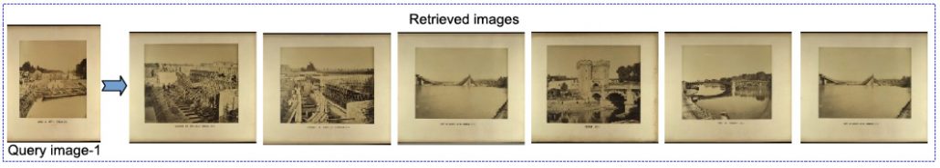
Image retrieval by content similarity, by querying the collection of the Nicéphore Niépce Museum: for a query (left), the six best results are presented in decreasing order of similarity, from left to right.
Within the thesis of Neelanjan Bhowmik, in the MATIS group of the LaSTIG Laboratory at IGN, France, we have addressed this task by studying solutions to the description and indexing of such contents, with application to query-by-example in large collections of images. This area of research takes place in the domain of Content-Based Image Retrieval (CBIR), which concerns several disciplines, in particular Image Analysis and Databases.
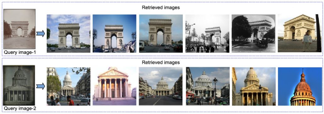
Illustration of cross-domain image retrieval by content: the query images are old pictures taken from the Nicéphore Niépce Museum collection while the dataset is from Flickr. For each query, the six best results are presented in decreasing order of similarity, from left to right.
Here, one difficulty is the variety of the contents within a collection and across collections: by the proposal of the joint use of several image-based descriptors, we have provided a response to the problem of cross-domain indexing, i.e. indexing in the potential presence of contents acquired at different periods, with different sensors or of different natures (photograph, postcard, drawing, etc.) and subject to post-processing.
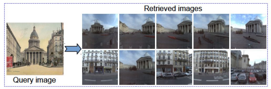
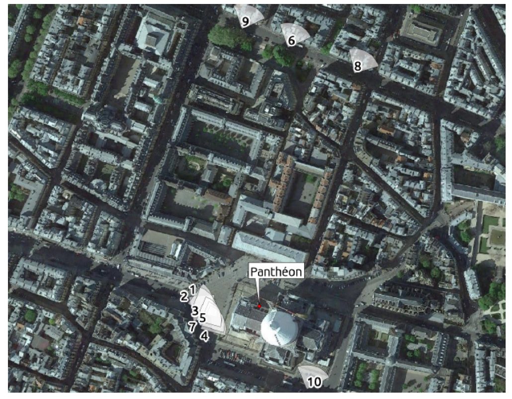
Cross-domain retrieval of an old illustration (Panthéon monument) in a georeferenced street-view dataset (IGN/Stereopolis mobile mapping device)
The second bottleneck relies on the proposal of scalable approaches of description and indexing, in order to deal with precise but voluminous descriptors, and with large datasets. One contribution of the thesis has concerned the study of a dedicated database index, able to deal with several descriptors per image and with large sets of images.
Automatic visual-based localization, by propagating the geolocalization of the ten best responses.
Associated publications:
- N. Bhowmik, V. Gouet-Brunet, G. Bloch, S. Besson. Combination of image descriptors for the exploration of cultural photographic collections. Journal of Electronic Imaging, 2017 (in press).
- N. Bhowmik, L. Weng, V. Gouet-Brunet, B. Soheilian. Cross-domain Image Localization by Adaptive Feature Fusion. Joint Urban Remote Sensing Event (JURSE), Dubai, UAE, March 6-8, 2017.
Valérie Gouet-Brunet and Neelanjan Bhowmik (IGN/LaSTIG/MATIS)
valerie.gouet@ign.fr and neelanjan.bhowmik@ign.fr (IRAA/CNRS-AMU)
http://recherche.ign.fr/labos/matis/arATOLL.php
The collegial church of Loches through the photogrammetric eyes of ENSG students
The shapes and colours of 12-century collegial church Saint-Ours in Loches (France) were measured with precision last autumn. Some 20 students from ENSG’s “Mastère spécialisé®” in Photogrammetry, Positioning and Measurement of Deformations, under the guidance of their supervisors, carried out a complete survey of the church. A wide range of techniques were coordinated, including remote-sensing, topometry, terrestrial and drone photogrammetry, lasergrammetry.
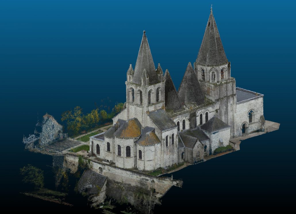
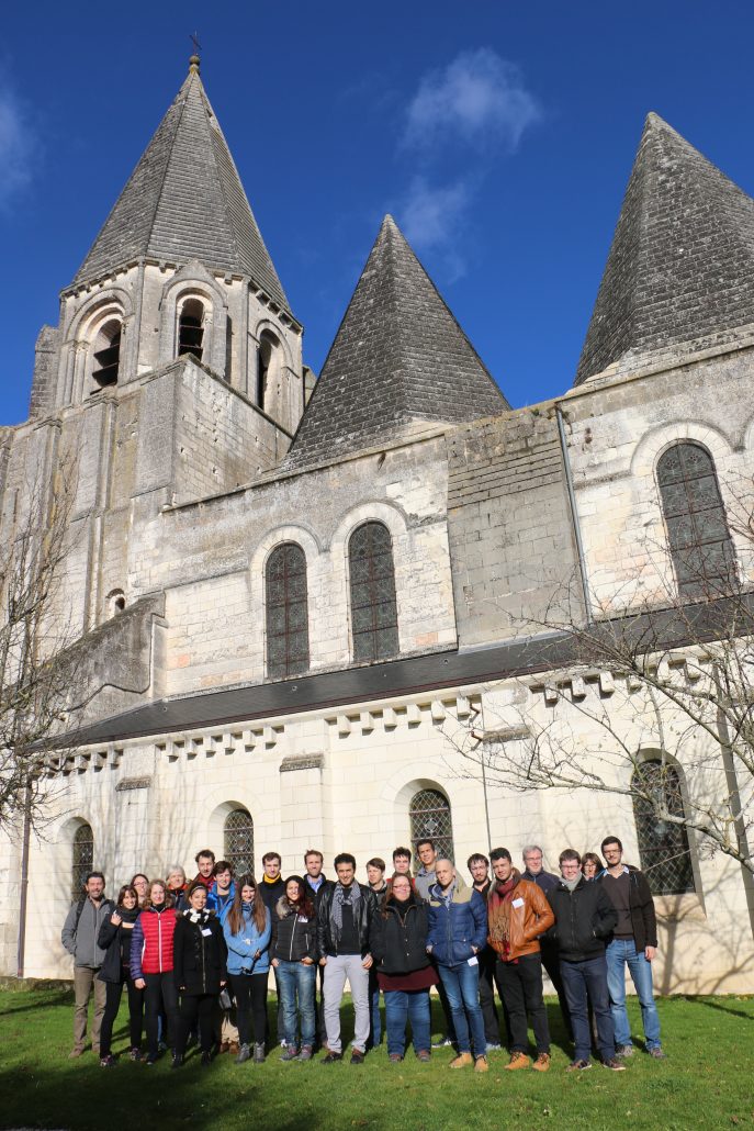
Both the exterior of the Romanesque church and its inner architecture, including the rarely-open crypt, can now be modelled in the legal reference system with a centimetric precision, in the forms of panoramic images, 3D point clouds, and orthoimages. The sculpted portal of the narthex was subjected both to a specific photogrammetric capture, at a very fine resolution, and to a multi-spectral shooting meant to help reconstruct the original paintings from the evidence of the residual pigments. The first results were computed in the evenings, and officially presented to the municipality before leaving. A rewarding moment after two weeks of intense field and office work!
Jean-Francois Hangouët
jean-francois.hangouet@ensg.eu
http://www.ensg.eu
The Hermitage – the Winter Palace Embodies and Revives Memories from the Russian Revolution 1917
This year 2017 marks the centenary since the Russian revolution that took place in 1917. It was a watershed in global history. Imperialism had been the politics of the great empires which gained colonies and riches from them. The Russian revolution changed the tide in many ways.
For me a vivid site for the revolution is the Winter Palace, the residence of the Russian monarchs. The actions of the revolution were depicted in old black and white films . Sergei Eisenstein made a propaganda film October: Ten Days That Shook the World ten years from the revolution in 1927/1928 showing how the monuments of the monarchy were destroyed and the violence took over. A sphinx made of granite standing along the Neva river is witnessing the violence in the film. The revolutionary scenes on the film display how crowds were entering high iron wrought gates and penetrating into the building and running in its large staircases in force.
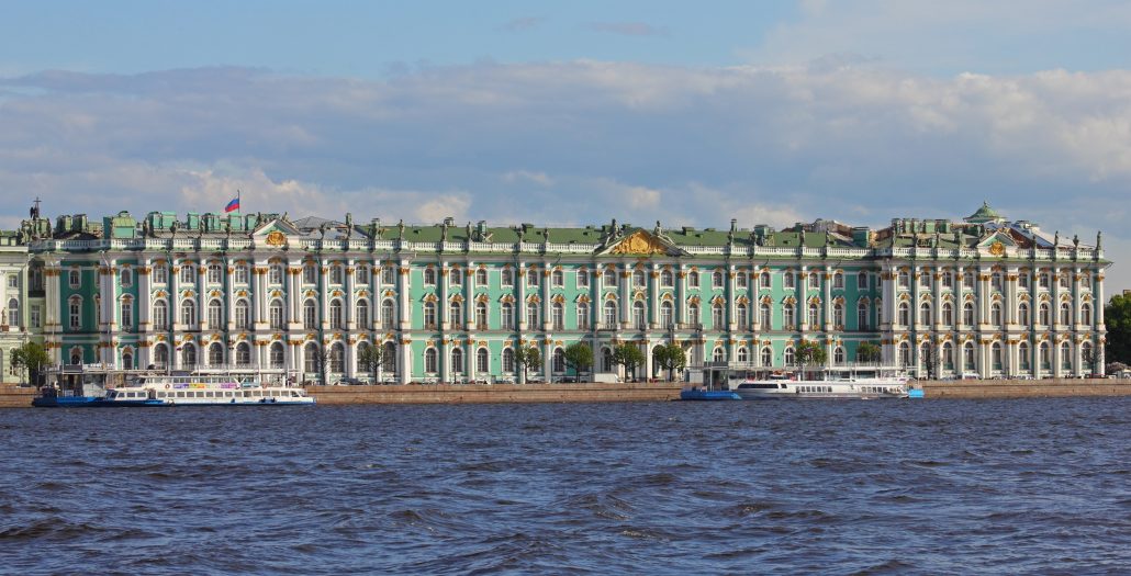
While visiting the site I have looked at the great staircase – this is it – the place where history turned, there it happened. It is a place in which changes in history are attached. The Winter Palace has served as a great museum known as the Hermitage both during the Soviet Union and the following Russia. St Petersburg has changed from Petrograd to Leningrad and back to St Petersburg. I had opportunity to visit the Hermitage both during the Soviet Union and Russia, as well as Leningrad and St Petersburg. One can only feel awe of that museum and its collections. Many riches from the imperial Russia are visible there. There is a real sense of Venice of the North in the architecture at the water. A cruise takes one to see the magnificent buildings along the Neva river, some built by huge slave workforce – reminding the conditions of the imperial world. The monumental malachite vessels at the Hermitage were a special wonder of my first impressions during the visit in the Soviet era, also all the beautiful paintings of the Renaissance masters.
During the second visit I participated in a conference and had a unique opportunity to lecture in the theatre of the Winter Palace and have drinks on its inner courtyard. The conference participants were led to special store rooms to see incredible wealth of the tsars: I remember a small golden chair encrusted with rubies, a gift from some prince from India to the Tsar. During the second visit I paid much attention to the architecture of the palace, features from the original Baroque style building from the 1730s finally to the parts to Rococo style. I also witnessed the Rolling Stones concert at the square in front of the palace and wondered who ever gave a permission to have such powerful noise that shook the square, its historical buildings and the items that it encompassed like in a small earthquake.
Picture by A. Savin.
As a Finn I have felt commonality with St Petersburg and its history. Finland only became independent from Russia during the year of the Russian revolution in 1917 – also 100 years ago. Finland had been part of the Russian Empire since 1809, the result had been the decision made by Napoleon and the Tsar Alexander I to divide Europe into the spheres of their interest in Tilsit. Russia won Sweden in a war and took Finland from the kingdom. Finland, however, received autonomy under Russia.
Helsinki became the capital that imitated the Russian style in its central architecture during that time: the style of the Senate Square has been characterized as the Petersburgian-Prussian Neoclassicism – it has also been compared to St Petersburg being a little St Petersburg. That is why in the Soviet era it served as a film stage for St Petersburg for Holywood movies. As a student I personally participated in the masses playing revolutionaries in Warren Beatty’s The Reds from 1981 including Diane Keaton and Jack Nicholson.
Anyway, let’s go back to the great building of the Hermitage in St Petersburg, the original stage. It had served as Tsar’s palace and carries the memory of the Romanov rulers, especially the last one, Nikolai II and his family. There is mysticism in that family, in its youngest child Alexei with a hemorrhage, the family’s contact to the odd priest Rasputin and his power over the family. There also remains the question why Nikolai II did not react to the needs of the Russian poor.
However, in the arts such as music, paintings and literature the time was a blooming period, but for Finland it was the time of oppression, Panslavism. Eisenstein’s film describes the destruction that archaeologists are later digging up in the layers of history. The fate and the execution of the Romanovs was unprecedented. Excavations in Jekatenburg have brought new evidence. The question whether the daughter Anastasia was executed with the rest of the family in Jekatenburg has been archaeologically resolved with dental evidence and dna studies: none of the family members survived even if the legend of Anastasia still lives on.
Despite of all the destruction we are fortunate that the Winter Palace was turned into a museum already in the Soviet era to preserve a window to the culture that preceded the revolution.
Minna Silver
A. Savin
mlonnqvi61@hotmail.com
Public Engagement through Crowdsourcing Lost Heritage
Two years ago, the so-called Islamic State (IS) released a graphic video depicting the graphic destruction of the Mosul Cultural Museum. Citing religious motives, they violently destroyed anything they could not remove from the museum. This sort of graphic destruction was certainly meant more to provoke than fulfil any religious obligation, especially since it is known that one of their main sources of funding comes from the illicit trade of antiquities. However, these acts of violence against cultural heritage is a global loss and despite the widespread call for digital documentation of cultural heritage, places such as Iraq which have been politically unstable since the American-led invasion of Iraq in 2003 have not had the advantage of these documentation efforts.
Following the destruction of the Mosul Cultural Museum, Rekrei (then renamed as Project Mosul) was launched as a platform to preserve the memory of lost heritage. Crowdsourcing simply cannot offer the quality of a carefully planned acquisition, and as such we must emphasise that Rekrei provides a way to preserve the memory: indeed the resulting 3D models allows us to interact virtually with lost heritage but they are never a replacement of what has been destroyed. Despite the shortcomings in image quality, perhaps one of the greatest values of such a platform is the public engagement aspect. Often people feel helpless in the face of the loss of heritage, particularly those with some sort of special bond with the heritage in question. By giving people a way to respond to these losses, it gives us the ability to take back what was violently stolen away from us. Users from around the globe have helped to create digital representations of this lost heritage (see Figure 1 and Figure 2).
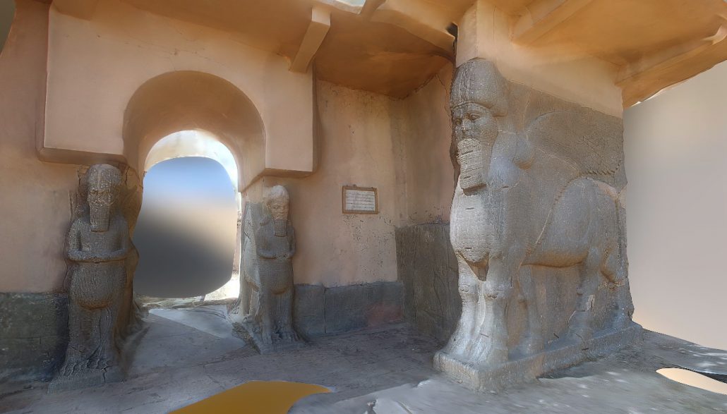
3D reconstruction of the entrance to Nimrud
The initial focus of Rekrei was solely on the Mosul Cultural Museum. We wanted to virtually recreate some of the pieces that were destroyed and then share them through a virtual reality museum experience. A few months after the project was launched, we were contacted by the Economist Media Lab, offering to collaborate with us on the creation of this museum experience. Throughout the summer of 2015, we collaborated to create the initial product, a VR experience that included several crowdsourced models, and a narrative piece that was presented as an audio track while the visitor explored the museum. Ultimately, the final iteration of the museum was reworked to be a guided tour of the museum, walking the visitor through a narrative that deal with the loss of global cultural heritage and efforts to bring some of these pieces back to life, even if virtually.
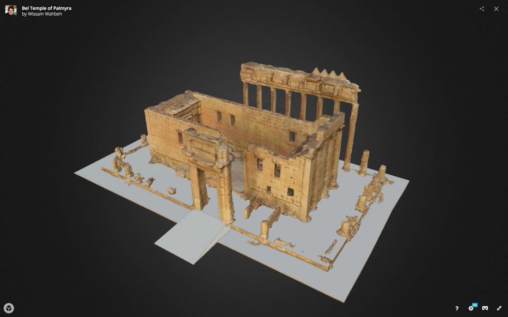
3D reconstruction of the Temple of Bel
Digital documentation is an important step towards the preservation of our global heritage. However, digital documentation preserves only the geometry (and maybe the colour) of our cultural heritage. One of the results of Rekrei is that we are forced to confront this loss. We emphasise that the platform allows us to engage with lost heritage through virtual reality, but it is not capable of allowing us to physically reconstruct a lost monument. And even if we were, such a reconstruction cannot replace the original monument that was lost. Instead, we hope that Rekrei can help to engage a wider public through active participation in the preservation of the memory of lost heritage. At the same time, we hope to continue to develop the platform to allow users to actively participate in the retelling of the stories of lost heritage, creating their own virtual experiences and sharing their voices.
The project and its portal are live, everyone is invited to contribute!
Matthew Vincent
vincent@fbk.eu
http://3dom.fbk.eu/projects/rekrei
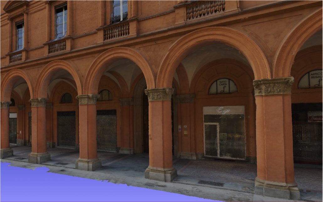
3D documentation of Bologna historical porticos
To any tourist arriving in Bologna (Italy) is immediately evident that the landmark of the city is the 42 km of arcades and porticoes running along the entire ancient city. Bologna owns an incredible variety of porticos coexisting within the same urban fabric, developed according to different typologies, materials and stylistic features coming from different ages. All this was made possible only thanks to the will of its citizens, who recognized the porticos as one of their strongest identity-creating elements. This way, the public porticos, as paradigm of social relations developing within a common space, become the reference model for a sustainable urban lifestyle which is unique in its genre.
The Bologna porticos were entered in the Italian Tentative List of the candidate sites to become a UNESCO World Heritage Site in 2006, with the application document available here.
The nomination of Bologna as a UNESCO World Heritage Site is part of the program of the current municipal City Council aiming at highlighting the porticos, not only as a high-quality architectural work, which in the past centuries has become a distinctive feature of the town, but also in its social, community and anthropological meanings, as a meeting place, a protected space: ‘a common good’. The nomination dossier stresses the worldwide uniqueness of the porticos of Bologna as cultural, material and immaterial heritage. For these reasons, the nomination project refers to different subjects and is divided into many levels of action, among which the preparation of the nomination dossier for the historical-scientific aspects. Other levels of action include the editing of the Management Plan, which will have to regulate the preservation, valorization, promotion and monitoring of the heritage, in order to emphasize the role of the porticos and to manage them in an innovative way, considering them in their cultural, social and economic dimension.
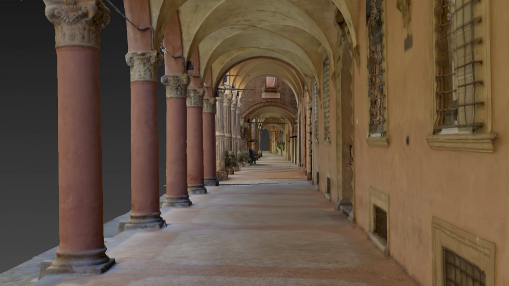
To support the UNESCO nomination, the DAI department of Bologna University carried out the realization of reality-based 3D textured models of a large part of the arcades, working in strict cooperation with Bologna City Council SIT department in order to integrate the 3D models inside their City Council database system. To meet the requirement of the digital reconstruction of the large and complex architectures, a joint project with FBK Trento was realized, identifying terrestrial photogrammetry as the most suitable, flexible, reliable and productive technique for the 3D reconstruction aim. An ad-hoc image pre-processing methodology was developed to increase the processing performances of the image orientation and dense image matching phases. Some of the achieved results, consisting in some 10 km of porticos, are shared online with a point-based viewer for valorization and dissemination purposes. From the point of view of the urban survey at the scale of the architecture this was an excellent test case since the “Bolognese portico” is not only an “open book” on the city and its history, declined in a large variety of forms and materials, but also a superset of the family of cultural objects that it belongs to. A complex system where traditional techniques of urban management and planning fails.
A main requirement to start new studies able to show new consistent ‘in-depth’ and key steps to start new management and planning techniques, conservation, enhancement and dissemination policies is to develop new framework and methods 3D-based to construct a powerful semantic 3D library of this Architectural Heritage, not only digital artefact with the aim of the mere visualization.
Cultural Heritage through Time
The European project Cultural Heritage through Time (CHT²), funded by the “Joint Programming Initiative in Cultural Heritage” JPI-CH, focuses on bringing together heterogeneous information and expertise to offer a better understanding of 4D (3D + time) digital products of CH sites. CHT² is working not only on the full integration of the temporal dimension and its management and visualization for evaluating CH elements through time, but also on creating a protocol to produce and optimize 3D/4D digital models of CH sites that is useful for architectural studies, analysis and research purposes. The project involves four different European research units: Politecnico di Milano, Italy; Newcastle University, UK; University of Salamanca, Spain; Stanislaw Staszic Scientific Association, Poland.
After the recent completion of the first two work packages, efforts continue to generate the final results of the four different study cases (one per country) and provide 4D models to disseminate in the remaining duration of the project, in approximately one year’s time.
At different working scales, Milan Roman Circus presents a special challenge due to the complex mixture of Roman, Medieval, Spanish, Habsburg and late modern structures and architectures. In this zone it is possible to see several traces of different historical periods, from ancient times until the densely urbanized structure of the present day (about 25 centuries). After the gathering of current and historical information, which includes both non-graphical (mainly bibliographic) and graphical (drawings and historical painting, maps, and photographs) resources, current efforts are focused on multi-source data integration and homogenization. On the basis of this, the most representative historic periods will be considered in the 4D model, to help in understanding the relationship between this important piece of Milan’s CH, and its current structure.
The UNESCO World Heritage Site of Hadrian’s Wall, being led by Newcastle University, is being analysed at three selected locations since the Wall encompasses a total length of circa 120 km in total. By means of a recent drone flight and two historical aerial surveys, conducted in the 1940s and 1980s, consistent 3D data models are being generated in support of the subsequent 4D CH analysis. The case study has recently been reinforced by the incorporation of Iapetus Doctoral Training Partnership PhD funding, commencing September 2017. In addition to the original CHT² project objectives, the aim of the doctoral research programme will be to assess and predict natural environmental impacts on CH landscapes.
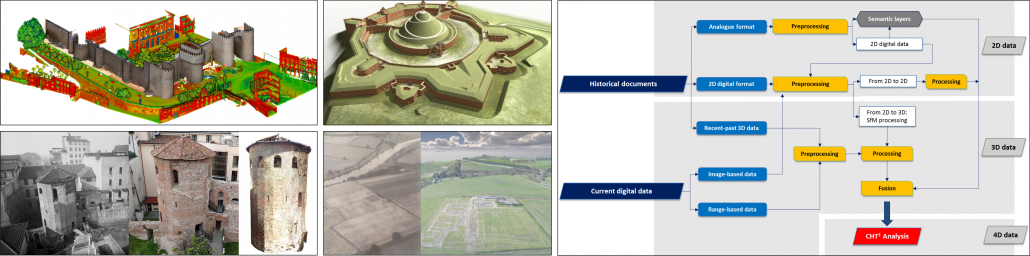
The Spanish partner is progressing with the case study of the Alcázar citadel in the medieval wall of Ávila. This follows the development of the 4D reconstruction and visualization methodology definition, as the first steps of the project. Data acquisition is already complete after the combination of terrestrial and mobile laser scanner with low altitude aerial images. Currently, efforts are devoted to citadel reconstruction (inside the wall) on the basis of the few actual remains, as well as the external defensive constructions according to the literal descriptions.
Finally, the Polish research unit is focused on implementing the 4D tools to share the partners’ results. Simultaneously they are completing the documentation of Krakow – the Fortress City (UNESCO site), combining present day TLS and drone mapping, and 3D models are being generated from historical plans.
Representing the relationship between time and space provides a powerful mechanism to visualize and communicate CH. As a result, CHT² models can be useful not only to study and analyse the past, but also to foresee possible risks in the future. We are involved in a project with great variability, but this challenge encourages us to improve the final models according to the end user’s needs and improve cultural dissemination, increase awareness of historical scenarios and enhance access to CH contents to researchers and non-academic stakeholders.
Follow CHT² progress here.
Pablo Rodríguez-Gonzálvez
pablorgsf@usal.es
http://cht2-project.eu
World War 1 Centenary in France – Vimy 1917, Canadians and the underground war
Completed in December 2016, the virtual visit of the Maison Blanche site in Neuville-Saint-Vaast (France) offers a 3D model of the underground network, as well as 3D photographic models of graffiti and sculptures carved by Canadian soldiers in 1917. The site was digitized in 3D by the research team from Pierre Grussenmeyer at INSA Strasbourg (UMR ICube 7357), using contactless measuring techniques based on a combination of laser scanning and photogrammetry.
The video has been prepared for the temporary exhibition dedicated to the Centenary 1917 – 2017: «Vimy 1917, Canadians and the underground war » presented until November 12th in Souchez, France (more info here). The exhibition has been organised by the Pas-de-Calais County Council in partnership with the French National Institute for Preventive Archaeological Research (Inrap), the Greater Lens-Liévin District and the Lens – Liévin Tourist and Heritage Information Center.
More information in Ottawa (Canada) at the coming CIPA Symposium, with the presentation of the paper «Centenary of the Battle of Vimy (France, 1917): Preserving the Memory of the Great War through 3D Recording of the Maison Blanche Souterrain, by A. Murtiyoso, P. Grussenmeyer and S. Guillemin.
Pierre Grussenmeyer
pierre.grussenmeyer@insa-strasbourg.fr
iMARECULTURE project, bringing underwater CH to the reach of the wider public
Succeeding in a very competitive call titled “Virtual museums and social platform on European digital heritage, memory, identity and cultural interaction”, iMARECULTURE H2020 Research & innovation project, has launched November 1st with a duration of 36 months. Elaborating over the call’s topic, the project focuses in maritime and underwater CH. The scope of the project is to address the challenges of bringing the underwater CH into public’s attention as something more tangible, by overcoming the limitations of time and space using VR & AR. At the same time will raise public awareness of European identity by focusing in maritime cultural heritage, which by default bridges different civilizations.
Virtual Reality (VR) and Augmented Reality (AR) are having a rapid development, but are far from being widely adopted. Companies release new Head Mount Devices (HMD), which will soon become as affordable as a desktop computer. Although driven by the gaming community, it is evident that their prospect is far from being fully exploited. New applications and content are necessary for this technology to be adopted in every day applications.
Virtual Museums (VM), on the other hand, have a lot more to benefit from VR and AR, than just being a real museum transposed to the web, or just an archive or database of 3D digital objects. They should provide tools so that to prolongue the museum experience while attracting visitors and enhancing their physical visit. Underwater Cultural Heritage provides an excellent prospect for VM, as it is inherently unreachable by the large majority of people.
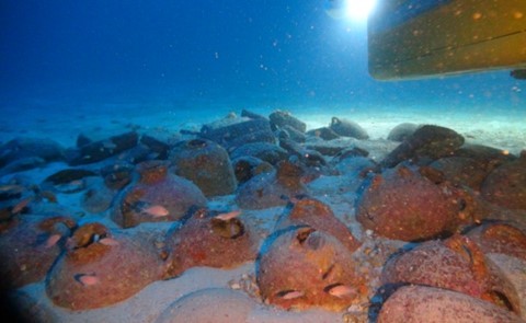
Xlendi wreck; images taken by the ROV Super-Achille, deployed during the photogrammetric survey carried out from AMU-CNRS and COMEX.
Focusing on personalizing the visits, VR will be employed for dry visits to archaeological sites, through interactive storytelling. Holographic screens, HMDs and VR caves, along with UW tablets with AR for divers in underwater archaeological parks, will be leverage immersive and personalized experience. Aiming at prolonging visitor’s experience, two serious games will be developed to raise awareness of maritime archaeology. 3D puzzles, available for 3D printing, will also allow visitors to further prologue their experience, from the comfort of their home. The user experience of VR and serious games will be evaluated through questionnaires and electroencephalograms.
Villa con ingresso a protiro. Detail of the site after restoration.
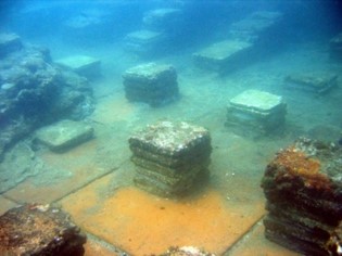
The three different test sites (Mazotos shipwreck, Xlendi shipwreck and Villa con ingresso a Protiro of Baiae underwater park) are selected to implement the multidisciplinary approach of the project and accomplish the objectives. The selected pilot test sites are representative of different kind of Underwater CH, of different states of environmental and geomorphologic conditions and of different periods, to present the users a wide variety of the common European maritime culture. Additionally, as a demonstration of how VR may affect the experience of a visitor in a museum, holographic displays are going to be deployed in Thalassa Museum. Regarding the technical planning of the pilot tests and trials, the state of the art of the technologies to be tested on each test site was described, analyzed and finally selected. ΑR implementation will be tested in Villa con ingresso a Protiro of Baiae site, where conceptual data exist and it is accessible by tourists. VR implementations will involve mainly dry interactive visits at home or in museums, using various immersive technologies. For museum and home dry visits, VR technologies will be utilizing full resolution authentic 3D data, while the dry visits from home will use downscaled data because of bandwidth limitations and IPR concerns. For applications under controlled environment, such as labs and museum areas, full scale resolution and detail will be used.
“For at least the first two years, VR will be for hardcore gamers and enthusiasts who are willing to invest in high-end computers capable of running the Rift.” Palmer Luckey, Oculus Founder.
“iMARECULTURE envisages to literally change the way we look, observe, understand and interact with our underwater cultural heritage”, Dimitrios Skarlatos, project coordinator.
“At the formal lunch at UNESCO’s top floor restaurant, I ended up doing an impromptu presentation of iMARECULTURE to all speakers and distinguished UNESCO officials there.”, Alexandre Monteiro, Invited speaker at the International Meeting on the Protection of Underwater Cultural Heritage Sites, UNESCO Headquarters, Paris (22-23 September 2016).
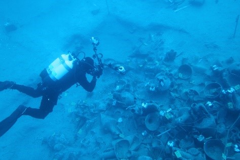
Mazotos shipwreck excavation documentation, using photogrammetry. @2016 UCY
Overall, iMARECULTURE envisages to design, analyze, develop and validate pioneer applications and systems in the context of Virtual Museums through collaborative and innovative research from a diverse group of scientists, researchers, archaeologists, experts and museums.
For more info, please visit our webpage, Twitter, Facebook, or YouTube channel.
International Conference in Rome “Documenting the Heritage at Risk”
May 19-20, 2017, Rome (Italy)
A two-day International Conference “Documenting the Heritage at Risk” was organized by the “Incontro di Civiltà” Association, chaired by Francesco Rutelli, in collaboration with ICCROM in Rome (19-20 May 2017).
On Friday at Palazzo Poli and on Saturday at the Ex-Planetarium of the National Roman Museum at Terme di Diocleziano, scholars and experts in art history, conservation and new technologies gathered from all over Europe, the United States, China and several Arab countries, as well as from UNESCO, ICCROM and major international organizations. Their discussions centred on the need to identify a universal code for cataloguing cultural assets at risk, in addition to adopting immediate commitments to intervene in war scenarios, crisis areas and environmental flash points, in order to safeguard affected heritage and to reconstruct what has been damaged or destroyed based on rigorous scientific criteria.
The participants also unanimously approved the Rome Appeal. The ten-point resolution will be forwarded to the governments of all Member States of the United Nations, UNESCO, and ICCROM. See here for more information.
Stratos Stylianidis and Pierre Grussenmeyer, members of the CIPA board participated in this conference giving the following presentations:
Evolution of Cultural Heritage Documentation Methods
A review based on existing archives from the Great Mosque of Aleppo
Pierre Grussenmeyer
Taking into account two decades of cultural heritage documentation projects managed by the author, the photogrammetric archives of the great Omayyad mosque of Aleppo (Syria) can be considered as a reference. The aim of this documentation collected between 1999 and 2002 by the Engineering Unit of the University of Aleppo was to provide topographical maps and elevations, planimetric and altimetric details of the walls and entrances, of the dome and the minaret of the Great Mosque. More, 3D vector models of each structure were provided. The Mosque has unfortunately been seriously damaged during the recent conflict in Syria. Based on this experience, a short summary of documentation tools and methods will be discussed, showing the importance of accurate documentation guidelines. The archives used in the Aleppo project can be considered as a valuable data source required for 3D reconstruction of destroyed or damaged historical monuments. But how was the documentation of this monument made today with the new technologies?
The documentation process has changed in the last decade, strongly driven by technology. Today, new approaches and tools are available, offering more efficient solutions to deal with the complexity of monuments and sites. The approaches are based on dense points clouds obtained from photogrammetric recording (terrestrial and more and more drone based) and terrestrial laser scanning techniques. The choice of the best workflow relies on several parameters such as the site configuration, the performances of the sensors, and criteria such as geometry, accuracy, resolution, texturing and georeferencing solutions able to produce the required deliverables. Terrestrial laser scanning techniques are today widely used for recording large and complex objects, sites and caves. Dense point clouds processed from images are used as an alternative or complementary method to laser scanning. Guidelines for the creation of a standardized documentation system should take into account the new tools and technologies. Recent photogrammetry tools also provide low cost solutions to merge archives and recent images, for a better understanding of damaged sites and reconstruction planning

Innovative systems for cultural heritage documentation
Efstratios Stylianidis
Raising awareness and visibility for our cultural heritage, at local, regional, European and international level, is necessary for the preservation of European culture. Modern perceptions for territorial development strategies require the simultaneous promotion of the cultural heritage assets by building and improving all infrastructures. European culture heritage preservation requires its protection. Within this framework, a series of activities are considered, such as surveying/mapping and documentation, conservation and restoration of our culture assets.
This work aims at presenting innovative systems in the field of photogrammetry and computer vision, which contribute to the recording and documentation of cultural heritage. This is more than imperative in the era where cultural heritage is at risk, from natural sources but also from disasters and criminal activities, such as those originating from the terrorists. We present the methods, techniques and tools that contribute to 3D recording and documentation of cultural heritage, with an emphasis in image-based and range-based techniques.
Pierre Grussenmeyer and Efstratios Stylianidis
pierre.grussenmeyer@insa-strasbourg.fr and stratos@geoimaging.com.cy
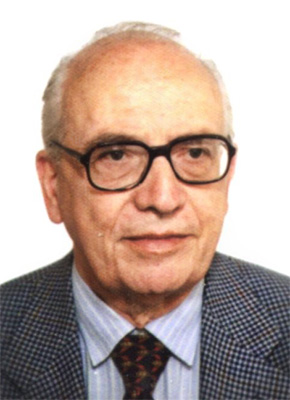
Prof. Mario Fondelli passed away
Mario Fondelli (26 ottobre 1924 – 17 febbraio 2017), engineer, full professor at the University of Florence. He started his activity in 1940 at the Italian Geographic Military Institute (IGMI) where he planned and carried out a lot of operations on the field and performed several studies and scientific researches.
Specifically as Chief of Studies and Project Section of IGMI he carried out considerable studies in theoretical and experimental researches in photogrammetry and spatial aerial triangulation (OEEPE- Organisation Européenne d’Etudes Photogrammètriques Experimentales).
During his academic career in Florence he also gave courses at the University of Venice, Modena; he was visiting professor at the Virginia Polytechnic Institute and State University in Blacksburg – Virginia (USA); honorary guest professor at the Municipalidad de La Plata (Argentina).
He was honorary member of CIPA of which he was President between 1988 and 1993. Member of Italian Icomos Committee. Academic Correspondent in “Classe di Architettura” of the Academy of the Arts of Design in Florence. Cartography scientific consultant for several public Institutions as Veneto and Toscana Regions. Very devoted to the safeguard of Cultural Heritage he participated, as volunteer, in the recovering of masterpieces of art and rare books (“Mud Angels”) during the flood of the Arno (1966).
He dedicated a lot of time in education of Photogrammetry for Cultural Heritage and Cartography. He was author of important books related to Topographic, Photogrammetric and Cartographic Science. Co-author of the Atlas of Venice, Atlas of Florence and Atlas of Genua.
Geomatics and Restoration 2017 (GEORES) Conference and Young Professionals Workshop
May, 19-24 2017, Florence (Italy)
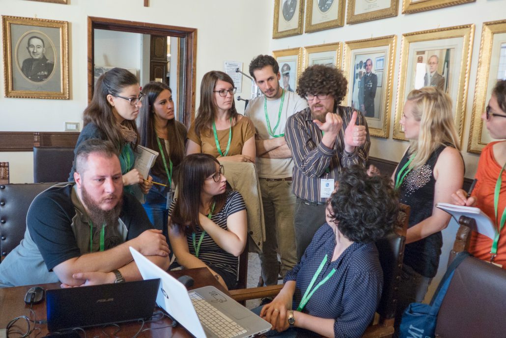
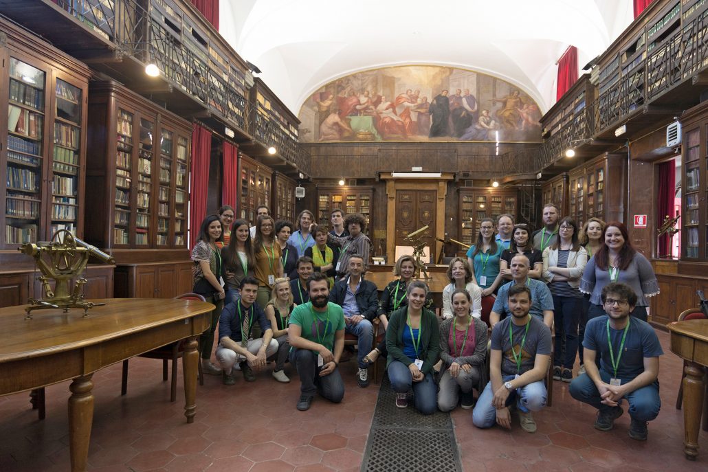
CIPA’s Vice President Mario Santana participated as an instructor at the GEORES2017 Preliminary Young Researcher Workshop, which took place in Florence (Italy) from May 19 – 21 May 2017. The activity was attended by 25 PhD students, postdoctoral fellows and young researchers from Europe.
The participants were confronted with advanced surveying techniques, such as 3D scanning, photogrammetry, virtual reality and panoramic photography throughout lectures and demonstrations. The beautiful Palazzina della Livia was used as the case study. After the workshop and on the first day of the GEORES conference, a special session was dedicated to present the results of this activity, which obtained very positive feedback.
Furthermore, CIPA also participated actively in the GEORES conference, Santana opened the conference with a keynoted entitled “Harnessing Digital Workflows for Conserving Historic Places Harnessing Digital Workflows for Conserving Historic Places”, underlying the importance of CIPA in bridging the gap between conservation specialist and geomatics professionals.
This conference counted with an attendance of over 150 experts from across Italy and the world in the fields of heritage conservation and geomatics applied to monuments. Professors Camilla Mileto and Fernando Vegas Lopez-Manzanares from the Univesidad Politecnica Valencia (Spain) and Enzo Santoro from the Geographic Military Institute (Italy) also spoke about the importance of conservation and information collected by geomatics experts. The proceedings of this meeting were published in the ISPRS Archives.
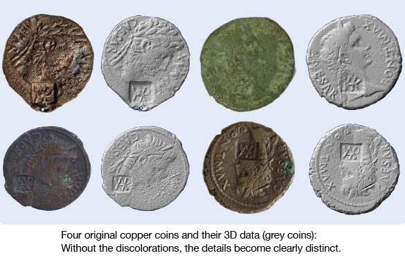
3D scans of countermarks on coins to retrace Roman troop movements
A handful of “asses” to trace historic events? The Archaeological Heritage Office of Saxony (Dresden, Germany) uses this innovative approach to study Roman copper coins (asses) in order to date sites of Roman troop activities between the rivers Rhine and Elbe.Numismatic analyses of these coins are the most important tool to reconstruct the dynamics of Roman troops movements between 7 and 9 AD, they help to establish relations between several sites. In addition to earlier studies using manual coin measurements in a 2D reference system, the 3D data of the SmartScan-HE now help to understand these particular archaeological sites and their relations to others. Furthermore, they establish a very precise chronological framework that allows for an attribution of these sites either to a more restricted period of time or even to an individual campaign.
Numismatic analyses of these coins are the most important tool to reconstruct the dynamics of Roman troops movements between 7 and 9 AD, they help to establish relations between several sites. In addition to earlier studies using manual coin measurements in a 2D reference system, the 3D data of the SmartScan-HE now help to understand these particular archaeological sites and their relations to others. Furthermore, they establish a very precise chronological framework that allows for an attribution of these sites either to a more restricted period of time or even to an individual campaign.
Learn more about this interesting project.
AICON 3D Systems live
- SEAHA – Conference and exhibition at the University of Brighton (UK), June 19-20, 2017;
- EVA – Conference and exhibition in St. Petersburg (Russia), June 22-23, 2017;
- CIPA– Conference and exhibition at the Carleton University of Ottawa (Canada), August 28 – September 1, 2017.
About AICON 3D Systems
AICON 3D Systems is one of the world’s leading providers of optical camera-based 3D measuring systems. The company, founded in 1990, develops and distributes systems for the business areas of inspection and testing including car safety and tube inspection. Since the acquisition of Breuckmann GmbH in August 2012, the product range also includes scanners for 3D measurement of complex geometries. On 1 April 2016, the AICON 3D Systems GmbH has joined Hexagon Manufacturing Intelligence, a leading global provider of information technologies that drive productivity and quality across geospatial and industrial enterprise applications.
The digital acquisition and documentation of cultural masterpieces is increasingly gaining importance — be it in architecture, fine arts, archaeology or paleontology. The contact-free 3D scanning technology of Breuckmann Scanners works in the museum as well as at the archaeological site. It allows handling delicate objects with the utmost care and provides detailed 3D data with high-resolution color textures for thorough studies without using the original. The white-light scanners are not 3D measuring systems bought “off the rack”, but rather are characterized by their high degree of flexibility: The scanner configuration is adjusted exactly to the customer’s requirements.
For more information, please visit this site.
For regular updates on our products and 3D scanning projects in Arts & Culture, please subscribe to our newsletter.
Dirk Rieke-Zapp and Martina Maier
ac_newsletter@aicon3d.de
http://aicon3d.com/start.html

