
Beirut’s Shattered Heritage: An Emergency Documentation
By Joe Kallas, Minna Silver and Ona Vileikis.
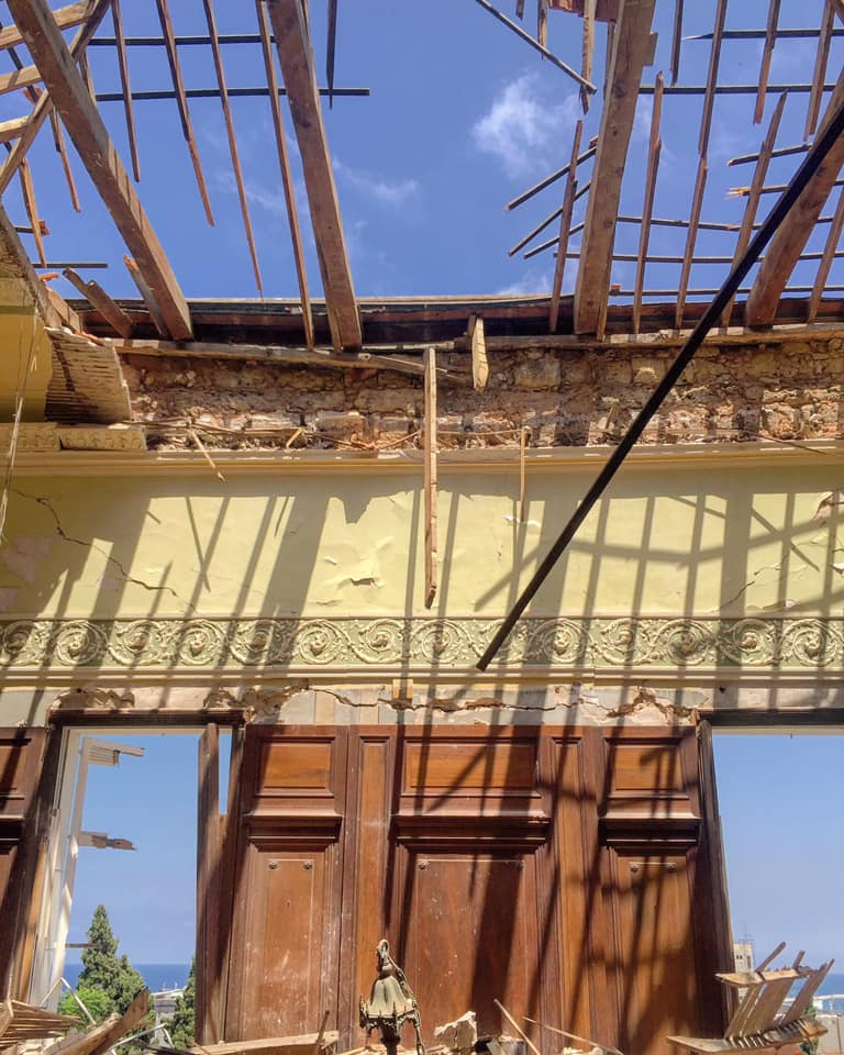
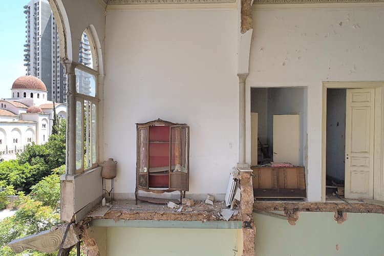
Shattered stained glass windows and endangered heritage left after the explosion in the harbour of Beirut in Lebanon, reflect the shattered hopes that the capital of Lebanon had during the decades of restoration in its historic sites. On 4 August 2020, a large amount of ammonium nitrate stored at the port of the city exploded causing irreversible damage to large areas of the historic city, among them the Gemmayzeh and Mar Mikhael neighbourhoods. A team of experts and volunteers, using digital technologies and high standards on documentation, are recording and assessing the cultural heritage that remained.
Biruta or Berytus, the ancient city of modern Beirut, has a long history that stretches over the Bronze Age starting some 5000 years ago. A small tell, a ruined settlement in the eastern bay region, witnesses the origins of a Bronze Age town with its Iron Age layers. Possibly from the Ebla archives in Syria, but obviously from the Amarna archives in Egypt, there are earliest textual references to Beirut. At various times Lebanon was ruled by princes under the vassalage of Syria, Egypt, Assyria, Babylonia, and Persia. The local people were Amorites and Canaanites, the latter identified with the Phoenicians.
The Iron Age saw the time of the flourishing Phoenician culture and the building of their own cultural identity. Phoenicians were the rulers of glass making, ivory carving and purple industry with textiles acting as famous traders in the Mediterranean region. Even, the name of Europe comes from a mythical Phoenician princess Europa who was abducted from Phoenicia to Crete. Later, the Greeks and Romans continued the production of these luxury articles. Archaeological layers and remains of the past, found under the modern urban milieu, tell us the long history of Beirut, but at the same time restrict any development in the city.
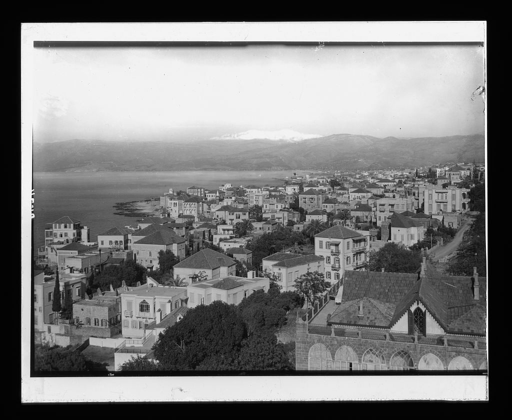
The heritage value of the Gemmayzeh and Mar Mikhael neighbourhoods dates back to the 19th century, with their architecture of the Ottoman and French mandate eras. They were among the first built after the expansion of the city of Beirut and of the few that still constitute a coherent historic urban fabric, only slightly affected by contemporary development. The Ottoman era architecture from the second half of the 19th century highlights residential buildings and villas with red tiled pitched roofs and large central halls featuring the famous triple-arched bay, emblematic of Beirut. Also, the 20th century three to four stories buildings of the French mandate era are architecturally significant, featuring balconies with decorative wrought-iron balustrades. Both types of structures comprise outstanding heritage values, and at the same time are precious for the owners and residents.
The buildings of the Ottoman era are the most vulnerable. Structurally, they are formed usually by a vaulted ground floor, the most stable part of the buildings, and on the upper floors, the central hall and the triple-arched bay divide the elevations in two. The loads of the high elevations and the pitched roofs are transmitted towards the lower parts via thin marble columns of the arches and thin sandstone masonry walls. A fine and beautiful architecture yet so fragile to withstand the pressure of such an explosion.
Many of the historic buildings that characterize the architectural heritage of Beirut have already been lost since the 90s. Due to the reconstruction works after the civil war, urbanization and globalization some developers have found an opportunity to demolish and build modern and futuristic unintegrated skyscrapers. Even the structures that were saved back then were always threatened by ‘unintentional’demolition. Now, after the explosion, professionals, and NGOs in the field of cultural heritage are concerned that structural damage may be used as an excuse to replace by high-rise the few buildings that remained.
As a response to the damage caused by the blast, heritage experts and alumni of the Center of Restoration and Conservation (CRC), created a volunteering initiative. This initiative is under the guidance of the Directorate General of Antiquities (DGA) with the support of the UNESCO Beirut Office, the International Centre for the Study of the Preservation and Restoration of Cultural Property (ICCROM), the International Council on Monuments and Sites (ICOMOS) Lebanon, the Association for the Protection of Historic Sites and Buildings APSAD and Blue Shield Lebanon. Right after the blast, the volunteering team carried out a quick survey and assessed the damaged historic buildings. The team started with the emergency propping interventions for the buildings at high risk of collapse. Under the initiative, a team of local members of CIPA Heritage Documentation volunteered for the 3D documentation and photogrammetric survey.
The main mission of the documentation team is to digitalize all the historic buildings post-explosion, prioritizing the buildings at high risk of collapse. The overall aims of the 3D documentation are: 1) to report the current state of the buildings after the explosion; 2) to provide structural engineers with 3D models of the most critical buildings for analysis; 3) to provide the architect restorers with graphical models and drawings where they can quantify the needed work and materials for future restoration projects; and 4) most importantly, to have a graphic and scientific documentation of the buildings as a record for posterity in case of any sudden collapse.
How are we working on the documentation?
Data Capture: The area was divided into several zones, and each zone was assigned to a team member to cover it. Ground-level images are being acquired using a NIKON D800 Digital Camera or similar. Aerial imagery is taken using DJI Phantom 4 Pro Drone provided by the DGA and operated by its qualified staff, S. Germanos and N. Gergian, to cover the pitched roofs and non-accessible areas of the buildings as shown in Figure 4. Images are taken with large overlaps (≥ 80%). There are limitations due to accessibility and not all buildings are captured completely. For example, it is difficult to control the drone around the buildings separated by very narrow alleyways covered by electrical wires heavily covered by garden trees.
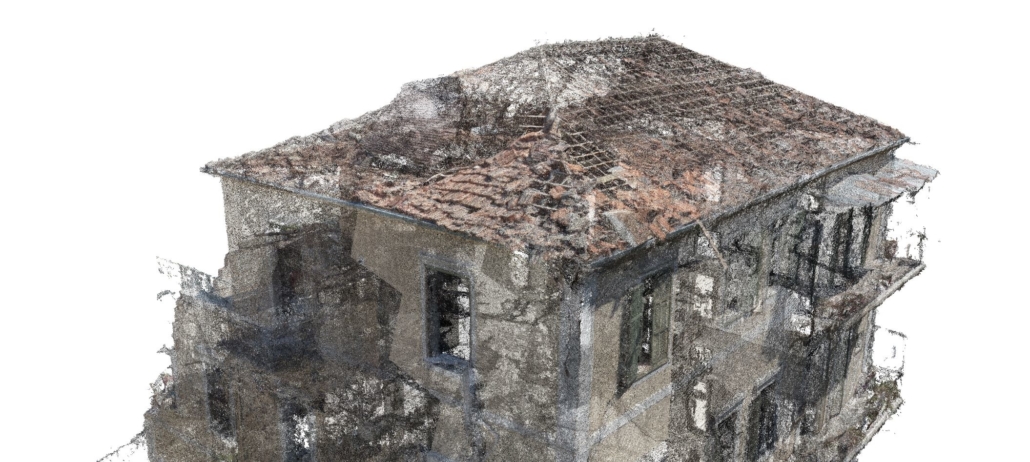
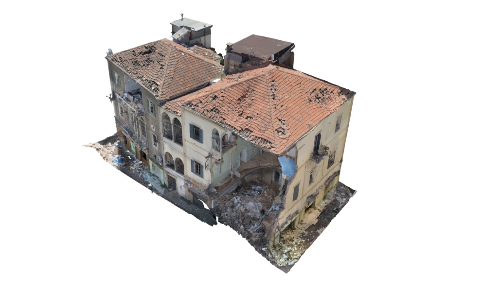
Data Processing: The photogrammetric 3D models are processed with Agisoft Metashape Professional 1.6.2. During data processing, images are being masked to exclude unwanted areas of each scene. Out-of-focus areas on some of the images are being masked also to increase the quality of the imagery and reduce noise levels. The 3D models are being semi-automatically generated following four steps: 1) generation of a sparse cloud with an approximate calculation of camera locations and orientations during images acquisition. For this step, the accuracy and density parameters are being set on high. The sparse clouds are being cleaned afterwards according to reprojection errors; 2) Generation of a 3D dense point cloud. For this step, the quality parameter is being set on high and the depth filtering parameter is being set on mild (see Figure 5); 3) Mesh from the generated point cloud. In this step, the mesh is being generated from the depth maps created during the generation of the 3D point cloud. The quality and face count parameters are being set on high. The Meshes are then being cleaned from unconnected components; and 4) Finally, the texture is created to obtain good resolution textures from the original acquired photographs (see Figure 6).
While it is our duty to preserve as much as possible our cultural heritage, we should eventually admit that we cannot save everything. A great opportunity is to systematically document it in case it vanishes permanently. Beirut’s efforts to document its shattered heritage, will keep the collective memory of the community alive, and will transmit the values and significance of these historic places to the wider public and our coming generations.
Bibliography
Abulafia, D. (2012) The Great Sea: A Human History of the Mediterranean. London: Penguin Books.
Bury, J.B. & Meiggs, R. (1985) A History of Greece to the Death of Alexander the Great. London: MacMillan.
El Amarna (EA) letters. Rainey, A. F. (2014) The El-Amarna Correspondence (2 volumes). Handbook of Oriental Studies, Section 1, The Near and Middle East, Vol. 11, ed. Schniedewind, W. M. & Cochavi-Rainey, Z., Leiden: Brill.
Lawler, A. (2011). Rebuilding Beirut. Archaeology, Vol. 64, No. 4, July/August 2011.
Perring, D. (2006). Beirut, Excavating the Souks, World Archaeology, Issue 16, March 7.

Leave a Reply
Want to join the discussion?Feel free to contribute!